Tasmania: An Epic Road-trip Part 9
Part 9 – The Bay of Fires
From Swansea we headed to the Bay of Fires, another popular destination in north-east coast Tasmania. Part of the day’s schedule was to stop in Bicheno to see the blow hole. Bicheno is a laid-back town of about 950 that is famous for the blow hole, and ‘wildlife and ecology park’. We had a very pleasant drive to Bicheno through very green flatlands.
Bicheno
After parking our car, we headed to the beach, but it was hard to
ignore and not read all the signposts along the coastal walkway. One signpost
showed information about the Penguin Tour. Another showed information about the Nature and Wildlife Areas where Tasmania tiger, quolls, wombats and a variety
of birds could be seen. Sadly, we did not have time to explore the wildlife in the park and
the surrounding beaches in Bicheno, we only had time for the blow hole. We were
greeted by an expansive beach of orange-colored granite rocks and boulders. There was a big triangular rock by the water edge. I assumed that the blow hole was closest to the triangular rock when I saw a couple sitting on the flat rocks as
if waiting for an event or something big to happen. At
first, we saw small amount of water shooting out of the blow hole. It wasn’t as
dramatic as I expected. We walked to the
triangular rock by the water edge and started taking pictures. When I saw the
waves crashing up against the rock walls, I came to realize that it was the
waves that drive the amount of water being shoot out of the blow hole. We
walked around the area to take some pictures and tried to time the waves so we
could get our camera ready for the big one. It wasn’t too long before a big jet
of water shoots out about 30 feet high. Thankfully, we were able capture it on video. (Click the video below)
Next, we headed to our accommodation in St. Helens and continued the drive along
coastal road with the view of azure blue waters on one side and the pine-tree,
eucalyptus forest on the other side. The color of the sky alternated between blue, gray and dark gray and rain. As we approached St. Helens,
it was extremely overcast. Ron mapped out an address of a restaurant where we
could get food before arriving in St. Helens. The navigation device led us to the right direction, but we missed it because the restaurant was hidden along a rainforest
with no sign of commerce. We found out later that the restaurant was part of a mountain biking resort area.
The Bay of Fires
We learned in the past few days that the weather situation in
Tasmania was extremely unpredictable. It was not uncommon to see blue skies and
rain within a very short lapse of time. So, even
though it was extremely overcast in St. Helens, we had hope to see the sunset at the Bay of Fires, about a 20-minute drive from our accommodation in St. Helens. Lenny
said that the sunset was so dramatic in a place like the Bay of Fires. We decided to have an early dinner before heading
to the Bay of Fires. We went to check out the restaurants at the wharf across our hotel but most of the restaurants dining hours were from 6:00pm to 8:30pm. So, Ron mapped
out some addresses looking for restaurants. We found a restaurant that was part of a hotel. Again, they don't serve dinner until 6:00pm. Lucky for us,
the husband of the restaurant host was the chef. So, she asked him if he could
prepare us takeout food by 5:00pm. We stayed for coffee while waiting for our takeout food. The restaurant outdoor seating
had a wonderful view of the bay. I saw lots of seabirds prancing on the shallow water. Meanwhile, Ron and Lenny tried to
map out how to get to the Bay of Fires and I heard the talk about going to ‘the Gardens” and saw it on the map. I thought we're going to visit another tourist spot near St. Helens: a garden with arranged flowering plants or with exotic plants from Tasmania. I was confused, but I was okay with it. As I said before, I let the travel guiding to Lenny and the driving to Ron. However, “The Gardens” was not like a place that I thought it to be. The Gardens
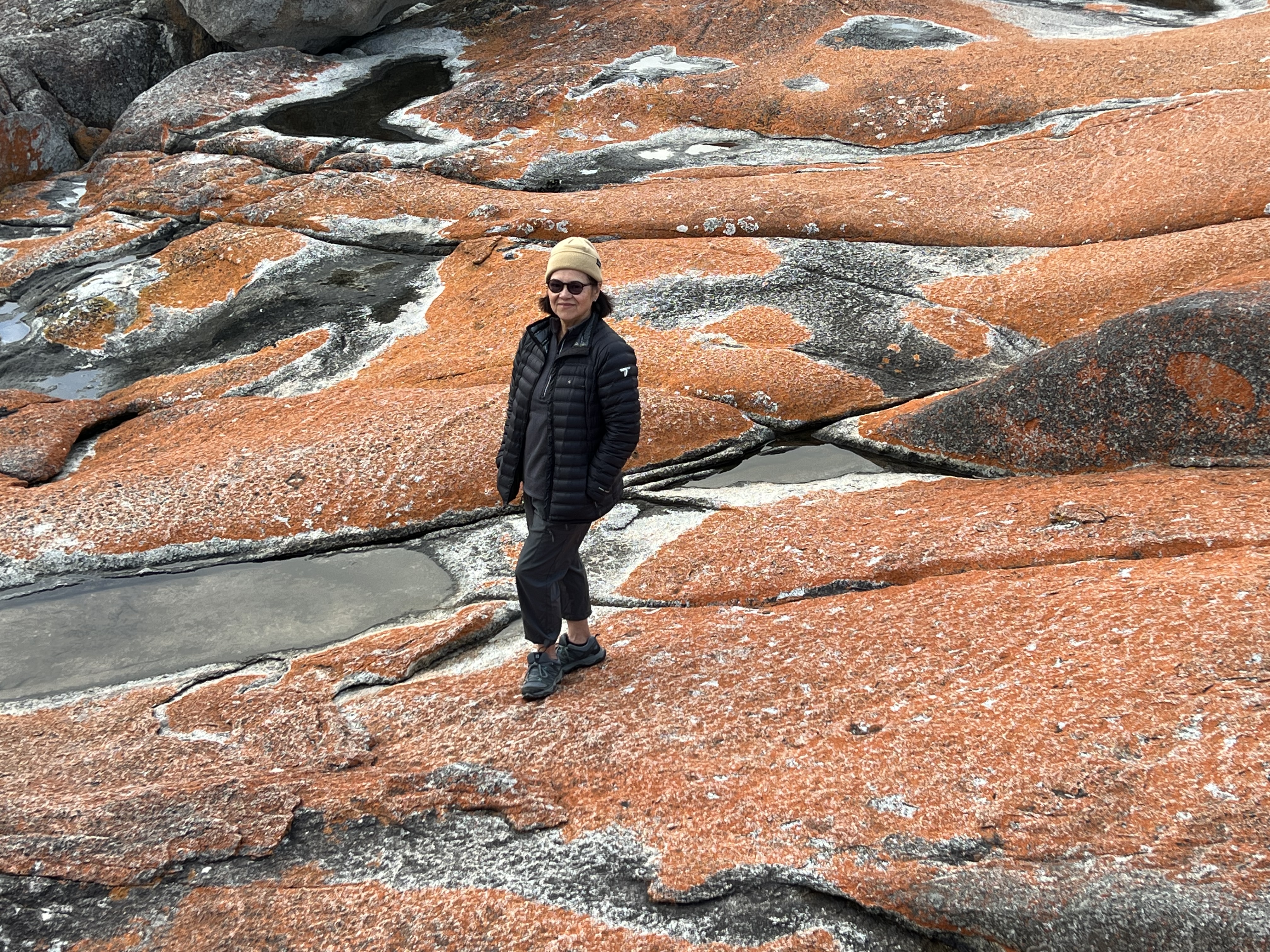
was a picturesque area in the Bay of Fires, overlooking pristine beaches and the orange-colored rocks at the edge of the ocean. It was named
by Lady Jane Franklin, the wife of the governor of Tasmania in the 1800s, due
to the abundance of wildflowers in the area.
"The Bay of Fires" is an intriguing name as well. It was hard for me to imagine the place. At first, I had an out-of-this-world image of lava fires floating on the ocean from an erupting underwater active volcano. The name Bay of Fires actually comes from Captain Tobias Furneaux as he sailed past in 1773, spotting Aboriginal fires lighting up the coastline. It could also apply to the brilliant orange lichen that grows on the granite boulders lining the bay.

The Bay of Fires stretches over 50 kilometers from Binalong Bay in the south to Eddystone Point in the north. The northern section of the of the Bay is part of Mount William National Park and conservation reserve which is a string of breathtaking beautiful beaches, lagoons and rocky bluffs. First, we walked and climbed the orange lichen-covered granite boulders and enjoyed the view of waters crashing up on the rocks. Then a photo-bomber (a rainbow) appeared while we were taking pictures of the colorful rocks. Then we drove for a mile or two to find the hidden beach that Ron and Lenny visited before. We walked along the powdery-white sand beach and soaked in the beauty of nature until sunset. I was grateful for the Tasmanian sun even though it was hiding behind a veil of thin cloud.

I mentioned in my previous blog that before our visit, I imagined Tasmania to be scarcely populated and mostly wilderness. After a few days in Tasmania, I realized that the reality was not far from what I imagined. We drove for long periods and hundreds of miles with no sign of commerce (tourist stores), but farmlands as far as the eye could see, sheep paddocks and some vineyards. I saw some live animals - wallabies, wombats and kangaroos in the wild, and lots of animal carcasses along the road. There are probably a gazillion acres of wilderness in Tasmania, except that they're now protected by Australia National Park System with boardwalks and well-maintained walking and hiking tracks.
PHOTO AND VIDEO GALLERY


NOTES:
- All photos by the author
- I have no material connection to the products, brand-names or tourist sites mentioned in the blog.
- Ron and Lenny (not their real names) live in Australia.


I never explored this destination still yet in my life, but after reading about his I decided that I will go there after my vacation in nyc.
ReplyDelete